Faulty Figure-8 Hike
East side of Sandias near Doc Long's
NMMC Info:
Class I+ - 4 Miles
Meet:
WF -
Car: to Doc Long PG 35 miles RT
Hike Description written by Terri & David Wallis
Elevation variation 55o ft.
Hike Description:
Depart Doc Long parking lot
($3 parking
fee or annual permit).
(Yellow)
Follow the Bill Spring Trail until its sharp left, uphill turn.
(Purple)
The trail sign varies, depending on who has corrected it last. Most maps show this as
the Faulty Trail, but it could also be considered a continuation of the Bill Spring
Trail and might be called the "New" Faulty Trail.
After the left turn follow the trail to the sign marking the
Oso Corredor Trail.
Take the left (lower) fork and continue to Sulphur
Canyon.
A short distance before intersecting the Sulphur Canyon Trail is the
intersection of the original (or "True") Faulty Trail.
(White)
Follow the "True" Faulty Trail back to its intersection with
the Bill Spring Trail.
Cross the Bill Spring Trail and creek and continue along the Faulty
Trail to the old road bed.
At the last curve in the old road bed, the Faulty Trail continues over a small ridge
and angles toward Barrow Canyon, at which point, one can cross the road or walk
through the culvert and contine north along Barrow Canyon. This stretch of the
Original Faulty Trail is sometimes referred to as the "Mystery Trail."
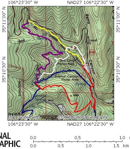
follow the old road bed until ends at a pile of large boulders.
Go around the boulders and drop down the hill to the Doc Long parking
lot.
Map (Hike route marked in
yellow, purple, & white.)
Map 2
(larger area variation of above)
NM Mtn Club Website
MycoWest.net/hikes/figure8.htm
dmw
.
2o13-o3-27
~84p - 640